Do you drive when you’re in St Ives? If so, read on…
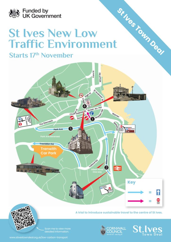
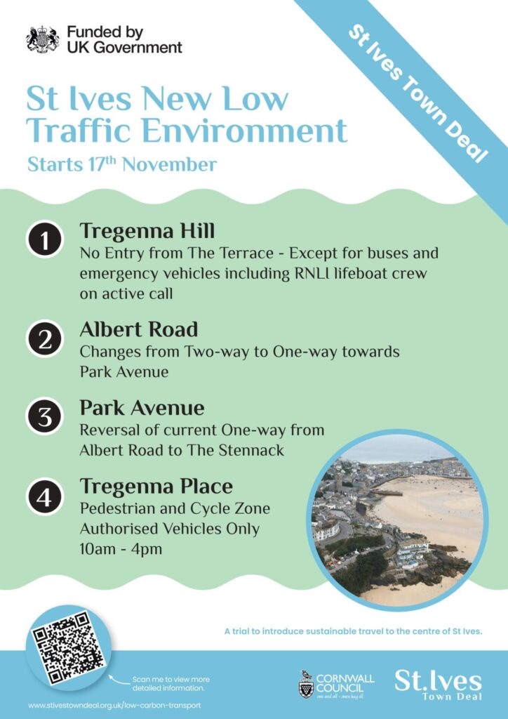
The St Ives Town Deal is trialling a new traffic plan for sustainable travel to the centre of St Ives which starts on 17th November 2025. This will affect how you drive into, around and out of St Ives for at least the next 6 months, possibly 12 months.
The aim of St Ives’ new “Low Traffic Environment” initiative is to ease the flow of traffic in and around St Ives and this summer, some of you may already have noticed the change in priorities at the top of Higher Stennack.
Fast forward to 17th November, there are 4 major changes that you should be aware of. We will be updating the ‘driving directions’ to all of our properties but in the meantime, please note the following:
Tregenna Hill
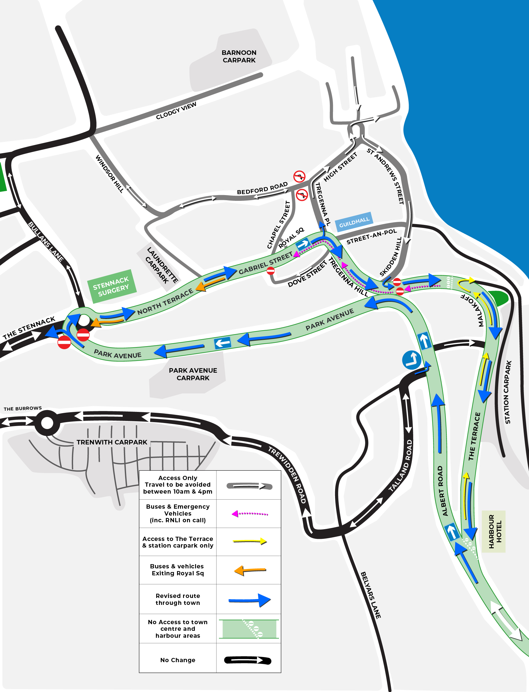
If you usually approach St Ives via Lelant and Carbis Bay, you will find that Tregenna Hill is closed to all traffic except buses and emergency vehicles (including RNLI lifeboat crew on active call). Instead, you will be directed along Albert Road where you can drive up towards Trenwith car park, along Burrow Road to join Higher Stennack to then drive down into the town; or, alternatively from Albert Road you will be able to drive the length of Park Avenue and join the middle of The Stennack from where you can also make your way down into the town. However, when leaving St Ives, you will still be able to drive up Tregenna Hill to make your way to Carbis Bay, Lelant and beyond.
Albert Road
This will change from 2-way to 1-way heading towards Talland Road and Park Avenue. By making this 1-way, the aim is to improve the flow of traffic and avoid the current bottle-neck where the road narrows.
Park Avenue
The direction of the 1-way system changes and will now run from Albert Road to The Stennack. You will no longer be able to access Park Avenue or indeed Park Avenue car park from The Stennack.
Tregenna Place
This will be a designated pedestrian and cycle zone between the hours of 10am and 4pm, 7 days a week where pedestrians and cyclists have priority but not sole use. However, if you are staying in town, you can still drive down The Stennack, onto Gabriel Street and turn left into Tregenna Place with care to access the Harbour, Downalong and town by car.
There are other changes too, including:
Bedford Road
There will be no right turn from Bedford Road onto Tregenna Place at all. Instead, traffic will need to drive down High Street. If you want to leave St Ives, you will have 2 options. The first option would be turn right at Market Place via St Andrews Street and Skidden Hill if you wish to drive through Carbis Bay and Lelant. Alternatively, you can drive down Lifeboat Hill, The Wharf and follow the 1-way system out of town to rejoin The Stennack and leave via the B3311.
Dove Street
Changing from 2-way to 1-way, there is no entry from The Stennack (just by the cinema and taxi rank). Instead, you will need to drive down The Stennack onto Gabriel Street, turn right onto Tregenna Hill and immediately right to access Dove Street.
Street-an-Pol
Remaining a narrow 2-way road, you can only turn left onto Tregenna Hill. You can’t cross over onto Gabriel Street or turn right onto Tregenna Place. You can still turn right at the bottom of Street-an-Pol onto Skidden Hill at the staggered junction but again, this is a narrow junction and may prove difficult for larger vehicles.
Skidden Hill
At the top of Skidden Hill by the Catholic Church, you will only be able to turn left onto The Terrace. There is no access to Tregenna Hill on the right.
The Terrace
There is no access to the town via The Terrace. Restricted access only along The Terrace to reach the railway station, station car park and Skidden Hill.
These changes will affect both local and visitor traffic and will take some time to adjust so we understand that traffic enforcement will be on the ground to help.
If you wish to avoid this altogether you can, of course, use the Park and Ride at St Erth but if you choose to drive into St Ives, please allow more time for your journey and be prepared for delays while we all get used to the changes!
For up-to-date news on these important changes, please visit the St Ives Town Deal web page. Please note that the current “artist impression” map is somewhat misleading and the Mayor’s office is in the process of producing a much clearer map to support these changes.
This post is based on the information provided by The Town Deal, specifically the artist illustration of the road layout from 17th November 2025 (see images above). We have been unable to clarify the exact details with Cormac or The Town Deal but if any further information becomes available, we will update the Blog.
Edited on 7th November at 1:55pm to upload the map produced by St Ives Town Council to show the new road layouts which is clearer than the one produced by St Ives Town Deal.